BGTSCC Region Map FEEDBACK wanted!

For Issues, Ideas, or Subjects That Do Not Fit Elsewhere

Moderators: Moderator, DM

User avatar
blazerules
Recognized Donor
Posts: 215
Joined: Sat Apr 29, 2017 7:43 am

BGTSCC Region Map FEEDBACK wanted!

Unread post by blazerules »

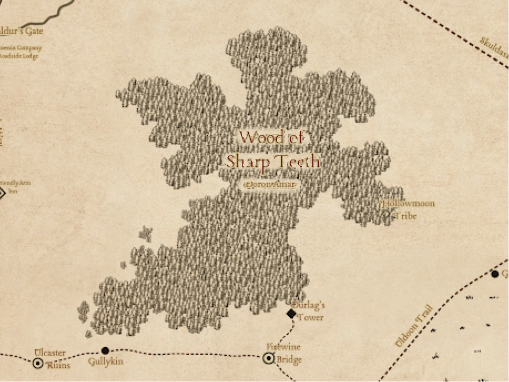
Hello! Ive been working on making a map that is custom tailored to our timeline and our region. While also being as accurate as possible. This is a draft map and I'll do a bit more clean up with the general assets placed, as well as a better bridge symbol that I've already made but didn't add yet. I'll need some help to make sure this is the best it can be for us. But to be in more detail...

The Issue:
1. Maps lack our BGTSCC specific locations.

2. The commonly used 3e map might actually be the worst available official map ever made. It is inaccurate in both location placements (The Twin Towers in Amn are NOT behind the cloud peaks that border our region. They are behind the small teeth mountains) and even geographical features (The hill of swords is located above the battle of bones and the northern part of the reaching woods is missing) while also having the general scale COMPLETELY off in different ratios (vertically and horizontally). It doesn't even properly convey the scale of the world.

The solution:
I've taken the cursed edition 4e map as a base, because this is funnily enough the most perfect and accurate geographical map to 1e and 2e out there. Likely using them as a layer in their program. Granted the locations are all over the place. And used sources from 1e, 2e supplements and other maps to accurately place locations in the map.

In addition I've uncovered the FR Interactive Atlas which helped me get a lot more locations that would realistically be present in our time frame as its a 2e map, its bigger issue is missing places (Its a 2e map, no Greenest etc).

What I need:
Help and feedback. Please help me with fact checking the map and making sure that every location makes sense. Ive gone through sources and tried to place things which make as much sense possible. But I'll also need help with any BGTSCC locations. As well as any aesthetic choices Ive taken on such as coloured font for certain kinds of things (Im thinking of going green for forests so the text is more readable).

Thank you! All feedback is appreciated.


Links
Links
Assets for wonderdraft they contain instructions.
The Wonderdraft map file download this to edit the map itself!
PNG map files of the layers

Version 6:
Image

Embedded for zoom: https://drive.google.com/file/d/1cJQMeR ... bbSMt/view

Edit:
Map has been updated with changes to V2

Changelog:
Hidden: show
V3:
Added Backlands label
Increased fields of the dead font size
Caution there be dragons in the sharp teeth
Changed Forest font to make it more readable
Added, and changed, Hollowmoon Tribe location (ugly lizards)
Added fort prominence
Added Uruk Lurra
Elturgard? Renamed to Elturel
Moved Gullykin closer to firewine and durlags per sources (Mention it being "a couple miles" and pretty close) as opposed to map sources.
Moved Ulcaster Ruins are closer to Beregost as per being a school near Beregost and mentioned in Beregost material "The school burned to an empty shell, which still stands on a hill east of town". Thus, moved closer.
Added Marsh of Tun (I missed a spot)

V4:
Winding Water Village added.
Changed Reaching Wood to have more forest around the river.
Changed Forest of Wyrms to have more forest on the river edges.
Added unnamed Trail through Eastern Green Fields.
Changed The Green Fields visuals to be a bit bigger so that they pass the uldoon trail. This way Greenest is within the Green Fields region. Makes more sense.
Paths a round Bladestone have been changed. Dashed and dotted line means an unpaved, unnamed trail. Dashed line means major trail, named, umpaved. Solid line means paved, named.

V5:
Changed Lake Weng, from Lake Neng (This seems to be an older edition name).
Added Ferry Crossing symbol.
Added Ferry Crossing to Elturel and Scornubel.
Added label to Trollford. Sorry Trollford.
Added 2 bridges to Eshpurta.
Changed the roads around Gullykin etc to reflect new path styles.
Created 2 new symbols: BG Location and BG Settlement. BG location is for locations that only exist in our timeline, Settlement is the same but a settlement.
Changed BGTSCC locations to match the newly created map symbols.

V6
Changed area label font colour to a dark dark brown for readability.
Moved some hills and mountains around for better consistency.
Added the fangs.
Moved Citadel Amnur a bit.
Added The Fangs.
Added a general coloured dragons in area symbol (Thank you DM Honk).

V Release
Icons for DM use, wonderdraft file release.
Image
Notes:
I called the unnamed trail to Ulgoths Beard, Ulgoths Trail. It would most likely have been called the trail to Ulgoths beard, then Ulgoths Beard Trail, then Ulgoths Trail as time passes. Maybe not officially but highly likely.

The trail through eastern Green Fields is unnamed. Meaning it's not major enough. Still, I want to have names for all the roads possible. Green Trail seems like the most likely. Since people using it would probably call it the green fields trail, then naturally shorten it to Green Trail. I left it ??? For now. There is far too little to go off here and I dont want to make such decisions.
Last edited by blazerules on Sun Apr 21, 2024 9:32 am, edited 27 times in total.
User avatar
Rhifox
Custom Content
Posts: 3964
Joined: Wed Jan 13, 2016 2:34 am

Re: BGTSCC Region Map FEEDBACK wanted!

Unread post by Rhifox »

Uruk Lurra in the rough northwest of Trielta Hills.

Northway Village where the Coast Way and the Trade Way meet on the road to Dragonspear. Winding Water village. A few other villages and hamlets that have come up before but I can't exactly place. Greypeaks don't seem to be named. Fort Prominence on the road between Soubar and Triel.

Might be good to note Boareskyr Village at Boareskyr Bridge, though that's not traditionally been on canon maps even though it's a canon location.

Some general proofreading for apostrophes and capital letters.
Tarina — The Witch of Darkhold, a dealer in spirits and black magic
User avatar
blazerules
Recognized Donor
Posts: 215
Joined: Sat Apr 29, 2017 7:43 am

Re: BGTSCC Region Map FEEDBACK wanted!

Unread post by blazerules »

"Uruk Lurra in the rough northwest of Trielta Hills."

In the hills or just northwest ish of it? Is there a second location I can go off of as well to make a more accurate placement?

For the winding water village, do we know where it is? Vaguely? Ill try traveling to it and see if I can figure out its general location from the present clues.

Please note any errors on the labels so I can correct or clarify, thank you very much.

Reserved for changelog and clarification:
Clarifications as people asked on discord, on what exists in our timeline would be very useful!
Elturgard might "exist" as just Elturel and Triel (At least in my talk with Rhifox)
Citadel of Strategic Militancy might have been rebuilt and exists. (Once again, spoke to Rhifox)

Not yet uploaded:
- Made fields of the dead label larger to reflect the region size.
- Added Backlands label.

Are these locations fine?

Image
Image
(Typo'd the village name, dont mind it. Its Boareskyr Village)
Image
Last edited by blazerules on Tue Dec 05, 2023 12:20 pm, edited 1 time in total.
User avatar
Rhifox
Custom Content
Posts: 3964
Joined: Wed Jan 13, 2016 2:34 am

Re: BGTSCC Region Map FEEDBACK wanted!

Unread post by Rhifox »

blazerules wrote: Tue Dec 05, 2023 11:48 am "Uruk Lurra in the rough northwest of Trielta Hills."

In the hills or just northwest ish of it? Is there a second location I can go off of as well to make a more accurate placement?
This is roughly where I placed it on a route update map for the eastern zones. You can also see North Tradeway/Fort Prominence zone here.
For the winding water village, do we know where it is? Vaguely? Ill try traveling to it and see if I can figure out its general location from the present clues.
On our roadmap map, it was placed about where you have Beldenshyn. But Rad-Icarus would be the one to talk to about its exact location.
Elturgard "exists" as just Elturel and Triel (At least in my talk with Rhifox)
Citadel of Strategic Militancy has been rebuilt and exists. (Once again, spoke to Rhifox)
For both of these, it's a 'might'. DMs need to be talked to about their exact status. Bloodhawk Hold has burnt down, but whether it was rebuilt yet and has become the Citadel is up to DMs.
Are these locations fine?
Northway looks fine. UL looks fine, though maybe a bit deeper into the hills. Boareskyr Village is a canon settlement, not a BGTSCC specific one.
Tarina — The Witch of Darkhold, a dealer in spirits and black magic
User avatar
blazerules
Recognized Donor
Posts: 215
Joined: Sat Apr 29, 2017 7:43 am

Re: BGTSCC Region Map FEEDBACK wanted!

Unread post by blazerules »

Rhifox wrote: Tue Dec 05, 2023 11:58 amThis is roughly where I placed it on a route update map for the eastern zones. You can also see North Tradeway/Fort Prominence zone here.
Thanks!
Rhifox wrote: Tue Dec 05, 2023 11:58 amFor both of these, it's a 'might'. DMs need to be talked to about their exact status. Bloodhawk Hold has burnt down, but whether it was rebuilt yet and has become the Citadel is up to DMs.
Edited the post to reflect the might.

If Beldenshyn wasnt a gnome village I'd say that's it hah. I'll ask them!

Added: Hollowmoon Tribe a lizardfolk tribe per Planehopper request.
User avatar
Steve
Recognized Donor
Posts: 8127
Joined: Wed Jul 08, 2015 5:42 am
Location: Paradise in GMT +1

Re: BGTSCC Region Map FEEDBACK wanted!

Unread post by Steve »

Nice work!

I would suggest that you create a paper colored background for behind the text/labels that are embedded in the woods.

Like this very quick and poor example:
Image

Talsorian the Conjuransmuter - The (someTIMEs) Traveler

The half-MAN, the MYrchanT(H), the LEGENDermaine ~ Jon Smythe [Bio]

Brinn Essebrenanath — Volamtar, seeking wisdom within the earth dream [Bio]
User avatar
blazerules
Recognized Donor
Posts: 215
Joined: Sat Apr 29, 2017 7:43 am

Re: BGTSCC Region Map FEEDBACK wanted!

Unread post by blazerules »

Oh yeah I could always increase the outline thickness. Could do even more but at some point it looks a bit not great. Point is readability, Ive been defaulting to 3 this is 5.
Hidden: show

Image

EDIT:
Can also increase transparency, add a light white glow effect. Its not too noticeable but does make a difference.
Image
Last edited by blazerules on Tue Dec 05, 2023 5:07 pm, edited 1 time in total.
User avatar
blazerules
Recognized Donor
Posts: 215
Joined: Sat Apr 29, 2017 7:43 am

Re: BGTSCC Region Map FEEDBACK wanted!

Unread post by blazerules »

Uploaded Version 3 with all the changes.

Edit:
If anyone wants to provide a better symbol for "BGTSCC Location" I wouldnt be against something more fitting. Has to be 100 by 100px.
User avatar
InsomnesCanis
Posts: 143
Joined: Sun Jun 17, 2018 8:06 am

Re: BGTSCC Region Map FEEDBACK wanted!

Unread post by InsomnesCanis »

great initiative, love it, kudos to the moon, and good cartography skills (Inkarnate?) ^.^!
I want to call you Santa because the inclusion of all the server-specific locations is the best Christmas gift ever!
It's not feedback but a question- do you intend to add the geo-political borders like the Amnian border, or the borders of the Ducal Lands? As I can imagine it can be quite taxing.
Lylan'Synor Syr'Asiryn, (aka Lily Summerheart)
Duelist, Dancer, Sailor & Engineer. A Warrior for Love, and Inquisitor of Beauty.
Captain of Doron Amar's Mathora Velharn || Deputy Headmistress of the Bladestone Foundation
The Wind Whispers (Love) - Geva Alon
User avatar
blazerules
Recognized Donor
Posts: 215
Joined: Sat Apr 29, 2017 7:43 am

Re: BGTSCC Region Map FEEDBACK wanted!

Unread post by blazerules »

Thank you very much! ^_^ It was made in wonderdraft, bought it ages ago and still had it so I thought I'd put it to good use. I will of course release all the layers and the raw file when I'm done to keep this future proofed.

Geo-Political borders are on a to-do list yes! This would however require more feedback from staff to well agree on the state borders. This would very, very likely be a back and forth process of agreeing on how things should be. This is something I would actually really love to do but I'm not sure how keen staff would be on this.

Here is a preview of what I vaguely toyed around with so far, dont mind the colours. Entirely placeholder they could be anything. I mostly just chose them at semi random to make things easier on me at a glance.
Hidden: show
Image

Also. . .

Version 4 is released!

TO-DO
Ferry Crossings! Icon is 2 wavey lines like the bridge to represent a ferry crossing (Elturel has a ferry crossing instead of a bridge)
Change/decide on a font colour for certain locations. I've been using white for general area font but this is non ideal. But they do need to be a different colour to not just make things too confusing at a glance.

Ferry crossing preview (Its in V5 not up loaded yet)
Hidden: show
Image
User avatar
DM Mimic
DM
Posts: 3566
Joined: Fri Oct 20, 2017 1:25 pm

Re: BGTSCC Region Map FEEDBACK wanted!

Unread post by DM Mimic »

The lake just south of the cloud peaks I believe is Lake Weng, not lake Neng.
User avatar
blazerules
Recognized Donor
Posts: 215
Joined: Sat Apr 29, 2017 7:43 am

Re: BGTSCC Region Map FEEDBACK wanted!

Unread post by blazerules »

Thank you kindly for the feedback!

Version 5 has been uploaded
Changed Lake Weng, from Lake Neng (This seems to be an older edition name).
Added Ferry Crossing symbol.
Added Ferry Crossing to Elturel and Scornubel.
Added label to Trollford. Sorry Trollford.
Added 2 bridges to Eshpurta.
Changed the roads around Gullykin etc to reflect new path styles.
Created 2 new symbols: BG Location and BG Settlement. BG location is for locations that only exist in our timeline, Settlement is the same but a settlement.
Changed BGTSCC locations to match the newly created map symbols.
User avatar
selhan
Custom Content
Posts: 1433
Joined: Tue Jun 09, 2020 7:40 am

Re: BGTSCC Region Map FEEDBACK wanted!

Unread post by selhan »

Thats a pretty nice damn map o.O
“We drink to get drunk, we get drunk to fall asleep, when we fall asleep, we commit no sin, when we commit no sin, we go to the Heaven's."

Bartender of the Broken Goblet - "What's yer Poison?"

Click to find out what time is it for the Bartender
User avatar
blazerules
Recognized Donor
Posts: 215
Joined: Sat Apr 29, 2017 7:43 am

Re: BGTSCC Region Map FEEDBACK wanted!

Unread post by blazerules »

Thanks! It's taken me ages. Although most of that time was gathering sources. After that things went rather smoothly :)

I do have two general notes/questions that can realistically only be answered by staff as I dont wish to make naming decisions on a map.


1) I called the unnamed trail to Ulgoths Beard, Ulgoths Trail. It would most likely have been called the trail to Ulgoths beard, then Ulgoths Beard Trail, then Ulgoths Trail as time passes. Maybe not officially but highly likely.

Could even play with it and call it Ulgoths Neck.

2) The trail through eastern Green Fields is unnamed. Meaning it's not major enough. Still, I want to have names for all the roads possible. As this makes it easy to just name a road if it ever comes up. Green Trail seems like the most likely. Since people using it would probably call it the green fields trail, then naturally shorten it to Green Trail. I left it ??? For now. There is far too little to go off here.
User avatar
Empoweredfan
Posts: 498
Joined: Tue Jun 05, 2012 3:14 am

Re: BGTSCC Region Map FEEDBACK wanted!

Unread post by Empoweredfan »

Really wish I could say anything more constructive than 'Thank you' and 'well done!'. But I honestly can't think of anything that would improve it. I love the initiative, and maps like this really help in getting situated in the setting. An underdark setting could also be nice to have, but might take away some of the mysteries of that realm (Sometimes it is nice to not be fully on top of where things are, that can't readily be viewed from afar).
Nawiel: Stubborn woodpecker from the deep.
- "Responsibility is a curse, importance, an illusion."


Deleniel Vanaer: Wood Elven Sor. . . cook.

If you put your foot in your mouth. . . don't start walking. . .
Post Reply

Return to “General Discussion”